What’s New
For an overview of the new features and enhancements in Geobank 2021 (version 11.2) , click on the following links:
New Features
Australian Minerals Reporting Templates
Geobank has been enhanced with functionality for MICROMINE to develop Apps for use within Geobank modules.
This release includes an App for producing Australian Minerals Reporting Template (MRT) files for regulatory reporting to relevant government departments.
Annual regulatory reporting now takes less time and with lower risk of errors. This app is available as part of the Advanced Reports module.
Enhancements
Depth Adjustment
Warnings are now provided where an adjustment will affect the thickness of an interval. This is done with a highlight in the Undo Log tab, Change in Thickness column, of the Depth Adjustment window.
In the Depth Adjust Undo Log the two columns previously called Diff have been renamed to Old Thickness and New Thickness; these are then used to calculate the value in the new Change of Thickness column.

Toggle the Save Order
A new Save option has been added to the Data group on the Depth Adjuster ribbon:
Click Reverse Save Order so that intervals are saved last to first. This can be used if the user is adjusting downwards. When set prior to clicking Save, the last interval is moved first, making space for the interval above it which will be saved next and so on, preventing intervals clashing into each other on Save.
![]()
The Reverse Save Order icon provides an indication of the current (Bottom-Up or Top-Down) Save order.
![]()
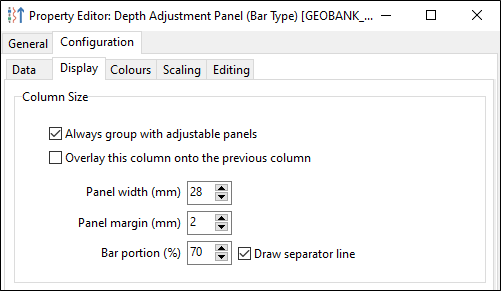
Configuration
In the configuration of a Depth Adjustment Process, a new check box option to group the display panel with adjustable panels has been added:
Plan View & Site Lists
A polygon select tool has been introduced to the Plan View ribbon for the purpose of spatially selecting drillholes within a polygonal area.
Click the Define Polygon tool to interactively define a boundary that can be used for site selection. The Show polygons check box must be selected in the Project layers tab.
Note that the user-defined boundaries you add are temporary, i.e. they are not saved to the database.

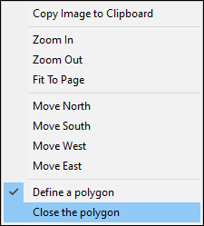
Click in the view to define successive boundary points:

Double-click to close the polygon (or select Close the polygon from the right-click menu).
The polygons you have defined can be used to select or deselect points, by first selecting the polygons and then selecting the points within them.
Polygon Selection
- Left-click selects a boundary polygon
- CTRL + click selects a user-defined polygon or obscured boundary in the order created
- Include SHIFT key to select multiple polygons
Points in Polygon Selection
- Press ALT + click to toggle the selection of all the points inside the selected polygons (excluding the section points)
Connectivity
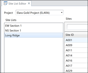
Using Geobank’s Connector, the Plan View can be used with the Site List tool to manage lists of drillholes spatially. Synchronisation now works two ways. The Site List Editor can be synced with the Plan View, which can be used to spatially select the holes that will be included or excluded from a site list. Conversely, you can use the Site List Editor to change the hole selection in the Plan View.
New Refresh and Save buttons have been added to the ribbon to allow your changes to be quickly reverted and saved.
Note: For performance and safety reasons, as a precaution it is recommended to turn off the Save Automatically function if you have a long site list and are selecting or deselecting points in the Plan View, as this will make individual calls to the database and there is no Undo function.
Datasets and Dataset Columns
The Form Designer workflow for selecting or adding datasets to a form has been simplified; a dialog showing existing datasets is immediately shown; from this new datasets can be created if required.
In the Form Designer Datasets panel, in the context menu, there is a new shortcut to add multiple columns and/or labels to a container in the form, in a single action:
- When using the shortcut to "Add Column(s) to Form" the resulting controls are automatically given an appropriate name for easy referencing.
- Likewise, when using the shortcut to "Add Labels(s) to Form" the resulting labels are automatically given an appropriate name for easy identification.

Versioning
Forms now have an "Object Version" property which can be set by the designer to a two-part version number (x.y), in order to easily track iterations of a form's development and distribution.
Folder Picker
A FolderPicker control is now available in the Form Designer toolbox:

Web Browser
Online or file-system PDF files can now be viewed by the WebBrowser control in forms. Files may also be downloaded and saved to the Downloads (or another) folder.
Sample Tag Rules
In Lab File Formats Metadata, Sample Tag Rules can be set for all user-defined QC-types; (previously this was limited to the first user type for each system type).
Additionally, the Sample Tag Rules can now be sequenced and targeted for specific user-defined sample QC-types.
New Default
In the Despatch Sample List 'Unselected' pane, 'Sample Tag' is now shown by default (Columns shown can be adjusted using 'Show Column Chooser').
Exports
A new "Run on Server" setting has been introduced in the configuration of Geobank Exports for faster performance of simple exports. Running locally is still recommended where complex queries are used (e.g. using WITH...)
Graphic Reports
More information has been added to the Geobank Help for Graphic Reports to better explain the usage and behaviour of Pivot Graphical Columns.
Find
The Find button dialog now automatically uses the current value as a default so that less typing is required to adjust the search string.
Home Screen
The Home screen 'Details' view style now has the option to hide one or more of the columns, making it easier to read on a narrow tablet screen.
Licensing
A Licensing section has been added to the Troubleshooting page in the Geobank Help, to assist in resolving certain contextual Licensing issues.