Drillholes
New Features
Database Upgrades
After installing the latest version, if they have not already been upgraded, the databases in your projects will be upgraded automatically when you open those projects. Backup copies of the old databases are created with a .BAK file extension.
You can use File | Utilities | Clean Up to remove these backup files.
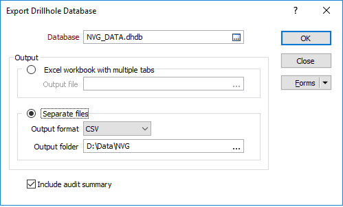
Export
Select Drillhole | Database | Export to export the data in a drillhole database. The option to write an audit summary to the chosen output format is also provided.
You can select an option to export all files in the database as individual sheets in an Office Excel 2007 XML-based (.xlsx) file, or export each file in the database to a separate Excel or CSV file.
Create Empty
It is now possible to create an empty drillhole database. Empty databases can be used as templates for drillhole planning.
An empty database must at least contain an empty Collar file, and may also contain empty (Survey, Interval and Event) downhole files. If any of these files is not empty, the database is invalid.
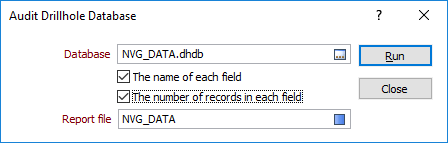
Audit
Select Drillhole | Database | Audit to report on the contents of a drillhole database, for example, to determine which data has been used for geological modelling or resource estimation. The following information is written to a Report file (.RPT):
- The name and the type of each file in the database
- The number of records in each file
Options on the form also allow you to report:
- The name of each field in each file
- The number of records in each field in each file
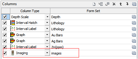
Downhole Imaging
An Imaging column type has been added to the Drilhole Log:
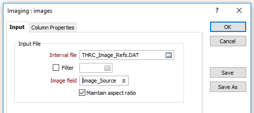
The Maintain aspect ratio option of the Imaging form will centre the image if the column is too wide. If the column is too thin then the image will have its right edge clipped to fit the column:
Synchronised Scrolling and Zooming
Click the Synchronise Views button on the Drillhole Log toolbar to add the current drillhole log view to a synchronisation pool or, if it is already synchronised, remove it from the pool.
When synchronisation is active, scrolling and zooming operations are synchronised between the views in the pool. For best results, those views will have the same page size.

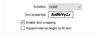
Expand interval height to fit text
On the Input tab of the Interval Label form, the option to expand the height of an interval in a text column to match the font height is now provided: This option is only available when the Rotation setting is set to NONE.
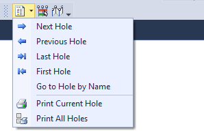
Hole Navigation
A new Copy hole name to clipboard button on the Drillhole Log toolbar, allows the Hole Name to be quickly pasted into the Quick Find Drillholes input box.

You can now navigate to the First hole and the Last hole, and Go to Hole by Name.
Text Wrapping
Automatic text wrapping is
Where there is a leading white space and the text is left-aligned, this is added to the offset. If the text is right-aligned, a trailing white space is used to balance the alignment.
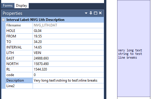
Tip: The ‘\n’ new line symbol may also be used to force the text that follows onto a new line.
Text Substitutions
Additional substitutions, @CollarInclination and @CollarAzimuth, can now be added to the Text frame for a Drillhole Log. If Inclination or Azimuth fields are blank they will be substituted with empty strings.
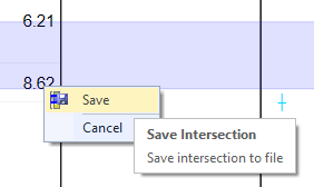
Save Intersection
You can now right-click to Save (or Cancel) the intersection you have defined interactively in the drillhole log display:
Toolbar
New buttons on the Drillhole Log toolbar allow you to toggle the display of the Form Sets pane, the Display pane, and the Properties pane, just as you can in Vizex.
To improve hole navigation, First Hole and Last Hole buttons have been added to the toolbar. Left and Right arrow keyboard shortcuts are also available when moving from the Current hole to the Previous hole and the Next hole.
Expand interval height to fit text
On the Input tab of the Interval Label form, the option to expand the height of an interval in a text column to match the font height is now provided: This option is only available when the Rotation setting is set to NONE.
Enhancements
Ignore validation errors
In many situations you may know that your drillhole data is invalid, but still want to display it. This often happens when you are evaluating third-party data, or compiling a master database from multiple, frequently duplicated, data sources.
With this in mind, the Drillhole Database Properties form has been modified to include an Ignore validation errors check-box on the Add Event File and the Add Interval File tabs.
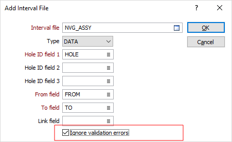
The state of the Ignore validation errors check box is saved in the database, indicating that you have opted not to check the validity of the file. Micromine will attempt to handle the file as well as possible without raising validation errors or warnings.
All drillhole validations that incorporate a drillhole database will honour the Ignore validation errors flag. If you wish to manually validate a file without clearing the flag, you can do so via Drillhole | Validate | Drillhole. This is the only function that ignores these flags altogether.
Drillhole | Validate | Auto-validate Options
The global Disable Auto Validate for this session option has gone, and is now replaced by a message box which gives you the option to set an Ignore validation errors flag (see above) for any files that fail validation. If you choose to set an Ignore flag, you can clear it at any time by editing the properties of the database.
Note: A major assumption and requirement of this process is that the Collar and Survey files are valid.
Generate Drillhole Pattern
Rather than define a constant Z value, you can now specify a From DTM, so that the process will adjust the upper-most elevation of each drillhole based on the topography of the DTM.
The layout of the Drillhole | Planning | Generate Drillhole Pattern form has also been improved. You can now use grid lists to write any number of irregular samples and assay fields to the output Interval file.
A square pattern is assumed and a staggered pattern option is no longer available.
Drillhole Imaging
Core image orientation options have been added to the Solid Trace tab of the Drillhole Imaging form:

When an image is oriented to Magnetic North, the left-hand edge of the unrolled image corresponds to a magnetic azimuth of zero. Use the additional rotation option to align the images to a different north point.
In High Side mode, a line along the top of the core cylinder corresponds to an azimuth of zero.
You can use the Mirrored option to adjust images acquired from inside a drillhole (a "wall view") so that they resemble a stick of core viewed from outside (a "Core view"). You must understand your data here, as mirroring is often applied in the imaging software before exporting to Micromine. Mirroring is not required for images acquired directly from drill core.
Graph Smoothing
You can now smooth the output when generating a drillhole graph in Vizex or the Drillhole Log.
To smooth curve data, specify a Smoothing size which is the number of points used in a moving average filter. You must specify at least 2 points. The greater the number of points, the smoother the curve.
A smoothing size of 11 will take each data point and average them with 5 data points above and 5 data points below, and then plot those points with their moving average values rather than their actual values.
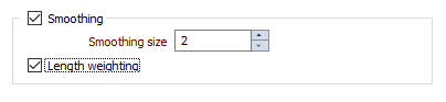
Select the Length Weighting option to apply a length weighting to the smoothed data. This may be useful for data with interval lengths that vary significantly.
Hole Depth label Offset
On the Hole Depth tab of the Display | Drillhole | Trace form, you can now specify how a hole depth label is positioned and specify an offset distance. The offset distance is specified in grid units.
If a bottom label (CENTRE) has been defined in addition to a hole depth label, the function will automatically prevent these two labels from overlapping. Entering an offset value allows you to further adjust the position of the hole depth label.
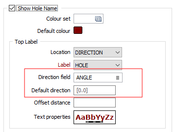
Hole Label Direction
On the Hole Name tab of the Display | Drillhole | Trace form, if the Location of the TOP label is set to AUTO or DIRECTION, the direction of the label can now be determined by the values in a Direction field which defines an additional rotation (positive or negative value in degrees).
If the Direction field is blank in DIRECTION mode, the Default direction is used instead and defaults to zero. If the Direction field is blank in AUTO mode, auto direction is applied.
Open Input File
Right-clicking to select Open Input File on a trace with downhole data will show the corresponding downhole file and highlight the current record. Right-clicking to select the same option on a trace with no downhole data will now show the Collar file and highlight the current record. Previously nothing was opened in this scenario.
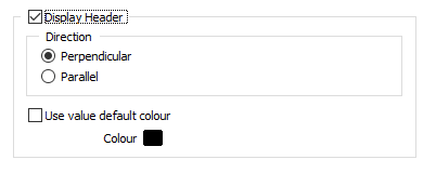
Interval Labels
On the Display tab of the Display | Drillhole | Interval Label form, you can now choose to align the header so that it is parallel to the trace, rather than perpendicular (the default).
Vizex Property Window
Non-compulsory fields, if they are defined in the Collar File and the Collar Attribute tabs of the Drillhole Database Properties form, are now shown in the Vizex Property Window.
The specification of a Drillhole Database is now mandatory in all drillhole compositing functions and calculations. Alternative (Collar, Survey and Trace file) input options are no longer supported (with the exception of Drillhole | Generate | Drillhole Trace).
The affected functions are:
- Drillhole | Calculations | Seam Roof/Floor
- Drillhole | Compositing | Downhole > Calculated Fields > Input Options
- Drillhole | Compositing | Bench > Calculated Fields > Input Options
- Drillhole | Compositing | Grade (Advanced) > Calculated Fields > Input Options
- Drillhole | Compositing | Interval > Calculated Fields > Input Options
- Wireframe | Report | Grade/Tonnage > Interval file > Collar file
Target file Merge fields and Flag fields are now automatically created and populated if they are left blank. This applies to all Merge functions including File | Merge | Micromine and File | Merge | Text.