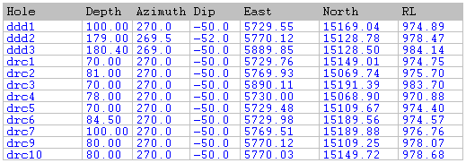
Collar file
The Collar file is made up of records that describe the location of the drillhole collars and the depth of each drillhole. The Collar file is made up of records containing:
Hole ID
A field containing an identifier for each drillhole.
Northing, Easting and Z
Coordinates that define the location of each drillhole.
Total Depth
The total depth of each drillhole.
Azimuth and Inclination
May also be stored in the Collar file where the drillhole direction is defined by a single survey.
Where the Collar file does not include azimuth and inclination information and a Survey file is not used, the holes are assumed to be vertical.
The data in the Collar file is obtained from the field geologist or surveyor's notebook. This could be supplied as hand written notes, a text file, or if you are using Geobank Mobile, a file directly compatible with the application.
Each drillhole should only be entered once in the Collar file (one record per hole). This means that the hole field must contain unique values.
If your drillhole data includes holes with multiple surveys, you must have a Survey file. The surveyed azimuth and inclination at the collar can be in either the Collar file, the Survey file, or it can be in both. In the latter case the survey in the Survey file takes precedence.
If wedged diamond holes are being logged, each wedge should be handled as a separate hole. The wedge collar position can be made the same as the parent hole or it can be located at the three dimensional coordinate of the wedge.
The way you distribute azimuth, inclination and other data between the Collar and Survey files will ultimately depend on your requirements. However, one method you could follow is:
- Keep all collar surveys in the Collar file.
- If there are multiple surveys for some or all of the holes, record these in a Survey file.
- Refer to vertical holes in the Collar file with azimuth of 0 and inclination of -90°.
This method allows mixed vertical, single survey and multiple survey holes all to be retained in the one Collar file.