Geology Compositing
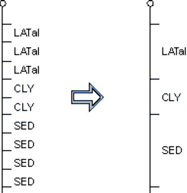
Drillhole | Compositing | Geology reads a drillhole assay file that contains many records with identical geology codes over successive intervals. From this, it creates a summary file containing a single record for each geological interval.
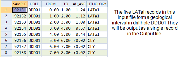
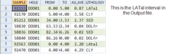
This function is generally used to prepare a geology file from an assay file that contains a geological description in every record. In a geology file it is only necessary to have intervals that match the changing geology. Geology Compositing reduces the quantity of geological information that will appear in a drillhole display or plot without reducing its quality.
The coordinates for each geological interval are averaged to recalculate the interval centres. To generate exact coordinates, use Drillhole | Generate | Downhole Coordinates.
When you run the function, a new file with the same structure as the input file is created:
The Drillhole | Calculations | Extraction function provides a more complex way to extract data into groups based on values in up to three variables.
Input
File
Double-click (or click on the Select icon) to select the name of an input file. This will be a drillhole Assay file containing the records (with identical geology codes over successive intervals) that you want to composite. If required, define a filter to selectively process the records.
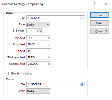
Hole, From, and To fields
In order to composite the data in an Assay file, you need to identify the Hole field and the fields containing the From and To depths that define each interval. Double-click to select the Hole, From, and To fields in the input file.
Thickness field
(Optionally) Double-click to select a Thickness field in the input file. If you specify a Thickness field, the function will calculate and enter the downhole length of each continuous interval in the output file.
Geology field
In addition to the Hole, From, and To fields, you must also identify the Geology field. While Hole name remains constant, the function looks for consecutive records with identical values in this field. Double-click to select the Geology field in the input file.
Blanks = Missing
Select Blanks = Missing if you want to ignore blank values in the input file. It is recommended that you select this option.
Output file
Double-click (or click on the Select icon) to select the name of an output file. If you select an existing file, it will be overwritten.