Expansion units
Expansion units is a factor that controls expansion of the original polygon dimensions, increasing the range of values that will be used for Kriging when the search ellipse extends beyond the polygon boundaries. If your polygon is a square, each side of the perimeter is expanded by the distance you enter here. This is shown in the following illustration.
Expansion units approximate the distance that the sectors of a polygon are moved. If the polygon is a square, it will be equal to the distance that the sectors are moved. The move a polygon departs from a square shape.
Polygons with a convex perimeter are expanded by a factor that depends on the range of values in the X and Y directions, as illustrated below. For this reason you should avoid polygons with concave re-entrants.
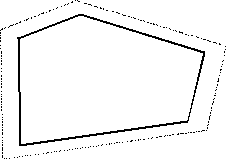
Polygons with a convex perimeter are expanded by a factor which depends on the range of values in the X and Y directions. Take care if you use polygons with concave re-entrants, because the expanded areas may overlap.
You can optionally restrict the data by clicking Outline Restrictions and entering an Outline file name and up to five sets of outlines.