Orientation and Geometry
The measurement of the orientation and the geometry of geological features is achieved by decomposing those features into lines and planes.
Planar features
- The orientations of planes are always measured using Strike and Dip, or Dip and Dip Direction;
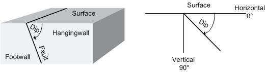
- Dip is the angle at which a vein, structure or rock bed is inclined from the horizontal. Down Dip is so called because it is always measured downwards at right angles to the strike.
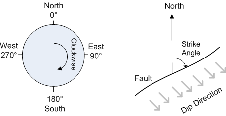
- Strike is the trend or bearing, relative to north, of the line defined by the intersection of a planar geologic surface (for example, a fault or a bed) and a horizontal surface such as the ground.
- Strike and dip notation is inconsistent and must include the handedness of the measurement to make it unambiguous. A right-handed strike is one where the structure slopes downwards to the right when viewed along the direction of strike;
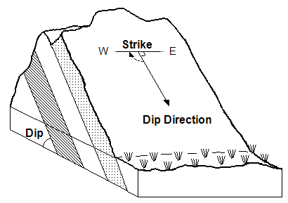
- Dip and dip direction notation has no such problem and is preferred for computational geology;
- Strike and dip direction are measured clockwise from north, ranging from 0 to 360°. Dip direction is always at right angles to strike;
- Dip is measured downwards from the horizontal, as a positive number ranging from 0 to 90°. There are no negative dips in geology;
- Although dip and dip direction are preferred, geologists usually measure strike and dip in the field because it is difficult to measure dip and dip direction without specialist equipment. Strike is easily converted to dip direction once the reading is taken.
Linear features
- The orientations of linear features are always measured using Trend and Plunge, although trend is sometimes called azimuth or plunge direction;
- Trend is measured clockwise from north, ranging from 0 to 360°;
- Plunge is measured downwards from the horizontal, ranging from 0 to 90°;
- Negative plunges are acceptable although uncommon in geology. Care must be taken; inconsistent sign usage is a potential cause of confusion;
- It is difficult to directly measure plunge and trend of geological structures in the field without specialist equipment;
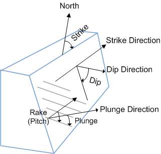
- Geologists usually measure plunge and trend indirectly, by first measuring the strike and dip of the plane containing the linear features, and then measuring the angle between the strike and the linear features in the containing plane. This angle is called the Pitch of the linear features;
- Strike, dip, and pitch are converted to plunge and trend using a stereonet or computer software back in the office.

The following diagram illustrates the relationship between strike (or dip direction), dip, and pitch, and also shows the calculated plunge and plunge direction:
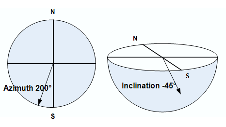
Drillholes
- Drillholes can be considered as linear features for computational geology;
- Drillhole orientations are usually measured using azimuth and inclination;
- Azimuth is measured clockwise from north, ranging from 0 to 360°;
- Inclination is measured relative to the horizontal, ranging from +90° (vertically up) to -90° (vertically down);
- Note how drillhole inclinations use the opposite sign convention with respect to geological lineations. Geological lineations are measured positive down, whereas drillhole inclinations are measured negative down;
- A simple rule for this difference is plunges are positive down, inclinations are negative down;
Engineering/Design Strings
- Strings can be considered as linear features for computational geology;
- String orientations are usually measured using azimuth and inclination;
- Inclination is measured relative to the horizontal, ranging from +90° (vertically up) to -90° (vertically down). This is the same sign convention as drillholes;
- Azimuth is measured clockwise from north, ranging from 0 to 360°;