World File
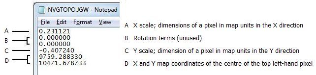
A World File contains the information needed to georeference an image. The illustration shows the contents of a typical World File. World Files are usually created at the same time as the image they accompany.
World files take the same name as the image but use a derived extension. Where DOS 8.3 naming conventions are used, the first and third letters of the extension are combined with a "w".
For example: If the image file name were image.jpg , the associated world file would be image.jgw.
The X and Y map coordinates are the coordinates at the centre of the top left pixel. Note that this differs from the reference coordinate displayed in Micromine, which corresponds to the top left corner of the image.