Exclusion Zones
Select the Use Exclusion Zones check box on the Design | Exclusion Zones tab to specify zones to which the generated stopes should be confined or from which they should be excluded. The zones can be delineated with polygons or wireframes.
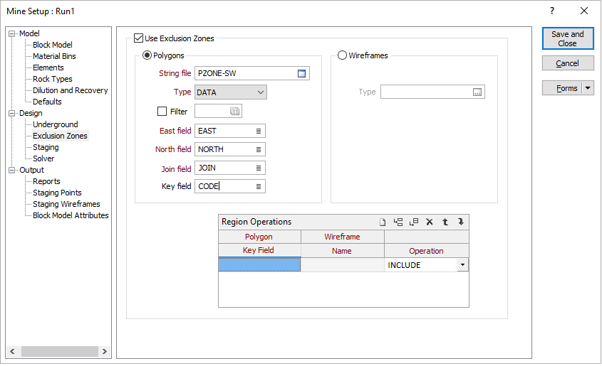
Polygons
Select to delineate the areal extents of the zones with polygons.
Polygons should be prepared in Plan View for this purpose.
String file
(Polygons only.) Specify the name of the file that contains the exclusion zone polygons.
Type
(Polygons only.) Select the type (DATA / SURVEY / STRING / ODBC LINK / MDB LINK) of file that contains the exclusion zone polygons.
Filter
(Polygons only, optional.) Select to specify a filter to be applied to the String file to identify the points to be included in the polygons. Specify the filter.
East field
(Polygons only.) Select the field in the String file from which the easting coordinates for the points in the exclusion zone polygons are to be sourced.
North field
(Polygons only.) Select the field in the String file from which the northing coordinates for the points in the exclusion zone polygons are to be sourced.
Join field
(Polygons only.) Select the field in the String file from which the join values for the points in the exclusion zone polygons are to be sourced.
Key field
(Polygons only.) Select the field in the String file from which the key values for the points in the exclusion zone polygons are to be sourced.
Wireframes
Select to delineate the zones with wireframes.
Type
(Wireframes only.) Select the type of wireframe to be used to delineate the zones.
Region Operations
Specify the following settings for each polygon/wireframe that is to be used to delineate a zone:
Polygon Key Value
(Polygons only.) Specify the value in the Key field for the polygon that delineates the zone.
Wireframe Name
(Wireframes only.) Select the name of the wireframe that delineates the zone.
Operation
Select whether the polygon/wireframe is to be INCLUDEd in or EXCLUDEd from the optimisation region.
Each polygon/wireframe ("sub-region") specified in the list will be processed in sequence as described below. All operations reference the block model specified on the Model | Block Model tab and use the centroids of the blocks in that model.
For the first sub-region:
- If Operation is set to Include, all blocks that lie inside the sub-region will be flagged as included in the optimisation region, with all other blocks excluded.
- If Operation is set to Exclude, all blocks that lie inside the sub-region will be flagged as excluded from the optimisation region, with all other blocks included.
For the remaining sub-regions, the operation specified for each sub-region will overwrite that for all preceding sub-regions and will have no impact on blocks outside the sub-region:
- If Operation is set to Include, all blocks that lie inside the sub-region will be flagged as included in the optimisation region.
- If Operation is set to Exclude, all blocks that lie inside the sub-region will be flagged as excluded from the optimisation region.
Example: If a string file contains a set of polygons, with each polygon assigned a key value of either "Yes" or "No" to signify whether the delineated zone should be included or excluded, the Region Operations grid list should be configured as follows:
| Polygon Key Value | Operation |
|---|---|
|
Yes |
INCLUDE |
|
No |
EXCLUDE |