Database Options
This dialog sets up options for the interaction between the SQL Server software and the database. To set Connection, Command, and Transaction timeouts, see Database Connection Environment.
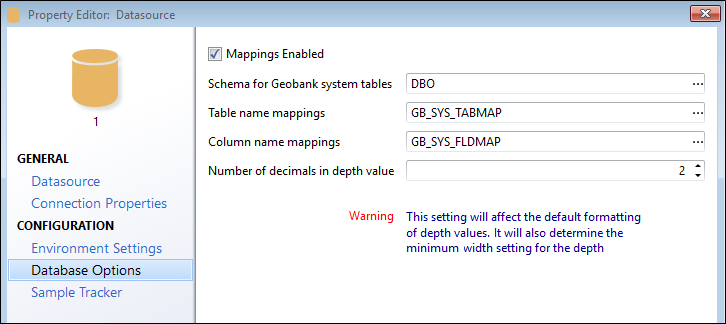
Mappings enabled
This option determines whether or not Geobank uses the standard GB_SYS_TABMAP and GB_SYS_FLDMAP tables to map table and field names in the database, to the system table and field names that Geobank requires to perform certain functions. Enabling this facilitates the flexibility of using Geobank with a customised database model.
This option is selected by default. When checked, Geobank will validate whether, in the specified schema, the specified table names exist and have the correct structure.
If mappings are enabled and the specified tables do not exist in the database, Geobank will launch the Upgrade process to add these tables so that the related functionality can be used.
In some cases, adding the mapping tables is either not possible or is unnecessary. Deselect the check box to disable the validation of schema, and mapping tables so that you can save a connection to a non-standard database, for which these mappings are irrelevant.
Disabling the System Table and Column Mappings will disable the use of Sample Tracker and Metadata built-in functionality. You will be prompted to confirm or cancel.
Schema for Geobank system tables
Geobank makes use of predefined datasets (called system datasets). Each dataset is based on an SQL query that returns a predefined minimum data content, represented by a number of columns with predefined names. All system datasets have a default implementation, based on the "standard" Geobank database structure. In keeping with the Geobank philosophy, these system datasets can be customised to suit individual user requirements, or to support various implementations of theGeobank database structure.
Table and Column Name Mappings
Geobank uses standard table names and column names for most processes. However, you can run these processes on any database that satisfies the basic data content requirements. This is made possible by the use of customisable SQL queries, supported by a system of table and column mappings. Standard table names and column names can be mapped to equivalents in your database, using the Geobank mapping tables.
By default, table and column mappings are stored in the GB_SYS_TABMAP and GB_SYS_FLDMAP tables respectively. The settings for the Geobank mapping tables can be found on the Advanced page of the Database Connection Property Editor. These tables can be used to store user synonyms for Geobank table and column names.
Table mappings are optional; i.e., if a specific mapping is not present in the mapping tables, then the default name will be used. In order to map one or more column names for a table, you also have to map the corresponding table name.
A mapping is performed by supplying a user equivalent for a standard Geobank table name or column name.
If any mappings are changed, the user should close and re-open Geobank to refresh the mapping used by the application.
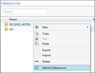
Refresh
Right click on the datasource and select Refresh to refresh the system table mappings and the schema.
Number of decimals
Specify the number of decimal places for Depth values.
This setting will affect the default formatting of depth values. It will also determine the minimum width setting for the depth.