Geobank Mobile supports the transformation of GPS Latitudes and Longitudes to Northings and Eastings.
If your device was disconnected when Geobank Mobile was opened, and you connect it, to reconnect you must select that device from the Connected Devices drop-down tool menu on the Main toolbar before you can take readings from that device. The status of the device can be seen using the Device Status panel.
Data
Use the fields in the Data section to specify which fields in your data table you want the GPS data to be sent to. When a GPS session is open and you click the GPS toolbar button, current GPS values are automatically written to the fields of the record selected in the open table.

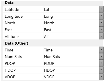
Latitude and Longitude values are specified in decimal degrees (DD.DDDD format). Easting and Northing values are calculated on-the-fly using the conversion parameters you have defined in the Spheroid Setup and UTM Zone.
If a field is left blank, that data will not be logged. If Advance on Read is selected, Geobank Mobile will move to the next record (or add a new one if at the end of file) when you log the GPS data.
DOP Precisions
Precision (PDOP, VDOP, HDOP)
A major factor in determining positional accuracy, is the alignment, or geometry, of the group of satellites (constellation) from which signals are being received. The geometry of the constellation is evaluated for several factors, all of which fall into the category of Dilution Of Precision, or DOP.
DOP is an indicator of the quality of the geometry of the satellite constellation. Your computed position can vary depending on which satellites you use for the measurement. Different satellite geometries can magnify or lessen the errors in the error budget described above. A greater angle between the satellites lowers the DOP and provides a better measurement. A higher DOP indicates poor satellite geometry, and an inferior measurement configuration.
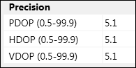
In the Precision panel, you have the option of getting Geobank Mobile to check the DOP values as you log each GPS position.
Note that the settings for Precision will not affect the calculation, as their sole purpose is to issue a warning message (and ask if you want to log the reading anyway) when the DOP readings from the GPS device are higher than those specified in the above panel.
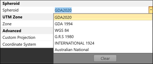
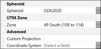
Spheroid Setup and UTM Zone
Geobank Mobile does not provide coordinate transformation; its purpose is to simple capture the data provided by the GPS device. The Spheroid and UTM Zone setting are there for two purposes:
- For labelling – the value in UTM Zone is appended to the value in Spheroid and when a reading is taken, this value is inserted into the column mapped to “Coordinate System” If you wish to label the reading with text other than those listed in the drop-down, then enter the description you with to use in the “Custom Projection” Field; this value will then be used as the label.
- As a UTM Zone check and, if necessary, a geometrical translation relative to the UTM Zone specified. When the reading is received, Geobank Mobile compares the Latitude and Longitude to the range expected for the UTM Zone specified. If there is no match, a warning message is displayed and the Easting and Northing values have an addition or subtraction applied to make the recorded reading relative to the Zone specified.
If you do not want a geometric translation applied to the Easting and Northing values for out-of-zone readings, or you are working in multiple zones and just wish to capture Latitude and Longitude, then putting in a Custom Projection name will turn off both the check and the geometric translation.
Spheroid
Choose the Spheroid from the drop-down list. It is essential that the Latitudes and Longitudes you will convert are expressed in terms of the same spheroid.
For more information see: Geodetic Datums and Projections
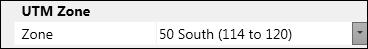
UTM Zone
Select the UTM Zone in which you are operating and for which geometric translations will be calculated
The UTM projection is based on zones which are spaced at 6° intervals around the globe starting from 180°. This results in 60 zones which cover the world. The central meridian of each zone is at 6 degree intervals starting 3° east of 180°.
When you select a zone you also select the Hemisphere in which the transformation is being done. In the Southern hemisphere the UTM projection uses a false origin of 500,000 East, 10,000,000 North. In the Northern hemisphere the UTM projection uses a false origin of 500,000 East, 0 North.
For more information on datums, coordinate reference systems and ellipsoids, you can browse the Geodetic Database at: http://georepository.com/home.html
Advanced
If you are using a projection that is not a UTM projection, enter the name of a custom projection and specify the name of a field into which the Spheroid + UTM Zone or Custom Projection label should be stored:
Log GPS Data
To log GPS data:
- Connect the GPS unit to the com port of your PC.
- Set the com port settings
- Enter GPS com port settings and device parameter settings as described above.
- Ensure that Toggle Overwrite is on (i.e. has an orange background).
- Navigate to the table that will collect the GPS data
- Click on the GPS tool button to get the GPS data.
![]()
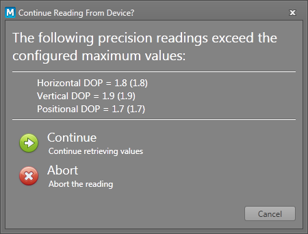
GPS Fix Modes and DOP Precisions
If there are insufficient satellites, the GPS unit may only be able to perform in 2D Fix Mode and so will not be able to record a GPS value for altitude.
A warning message appears as shown:

Click OK. If you wish to disable this message, clear the value for Altitude in the Device Support settings.
If any of the measured DOP readings are above the given thresholds, the following message appears. Choose to either continue or to abort the reading.
Comprehensive testing has shown that the speed at which Geobank Mobile obtains a GPS fix, either on start-up or when capturing subsequent locations, does not significantly differ from the speed of a GPS fix in the native GPS application.
Since locks must be obtained on broadcasts from a sufficient number of satellites, the first GPS fix may take some time.
A more extensive list of old local geodetic datums/ellipsoids and their modern geocentric (earth-centred) replacements are shown in Table 1 below:
| Region | Local Geodetic datum (old) | Geocentric (earth centred) datum (modern) | ||
|---|---|---|---|---|
| Datum Name | Ellipsoid Name | Datum Name | Ellipsoid Name | |
|
Australia |
Australian Geodetic Datum 1966/1984 |
Australian National Spheroid |
Geocentric Datum of Australia 2020 |
GRS 1980 |
|
New Zealand |
New Zealand Geodetic Datum 1949 |
International 1924 |
New Zealand Geodetic Datum 2000 |
GRS 1980 |
|
China |
Beijing 1954 |
Krassowsky 1940 |
China 2000 |
CGCS2000 |
|
Indonesia |
Indonesian Datum 1974 |
Indonesian National Spheroid |
Datum Geodesi Nasional 1995 |
WGS 84 |
|
South East Asia |
Indian 1954 |
Everest 1830 (1937 Adjustment) |
-- |
-- |
|
Middle East |
Ain el Abd 1970 |
International 1924 |
-- |
-- |
|
Europe |
European Datum 1950 |
International 1924 |
European Terrestrial Reference System 1989 |
GRS 1980 |
|
Russia |
Pulkovo 1942 |
Krassowsky 1940 |
Pulkovo 1995 |
Krassowsky 1940 |
|
United Kingdom |
OSGB 1936 |
Airy 1830 |
European Terrestrial Reference System 1989 |
GRS 1980 |
|
North America |
North American Datum 1927 |
Clarke 1866 |
North American Datum 1983 |
GRS 1980 |
|
Mexico |
North American Datum 1927 |
Clarke 1866 |
ITRF2008 |
GRS 1980 |
|
South America |
South American Datum 1969 |
GRS 1967 Modified |
Sistema de Referencia Geocentrico para America del Sur 1995 |
GRS 1980 |
|
Brazil |
South American Datum 1969(96) |
GRS 1967 Modified |
Sistema de Referencia Geocentrico para las Americas 2000 |
GRS 1980 |
|
South Africa |
Cape |
Clarke 1880 (Arc) |
Hartebeesthoek94 |
WGS 84 |
|
Central Africa |
Adindan |
Clarke 1880 (RGS) |
-- |
-- |
|
World |
-- |
-- |
World Geodetic System 1984 |
WGS 84 |
Table 1. Regional examples of old local geodetic datums and their modern geocentric (earth-centred) replacements
Notes:
- GRS = Geodetic Reference System
- This table is not definitive! There are hundreds of datums and thousands of coordinate systems; be sure to choose the right ones before carrying out any coordinate conversions
A geocentric (earth-centred) datum approximates the shape of the whole Earth, with an origin at Earth’s centre of mass. Because satellite navigation systems like GPS and GLONASS orbit that same origin, locations recorded by these systems can be used without conversion. In response, many countries have adopted new geocentric (earth-centred) datums over the last few decades, creating globally consistent coordinates.
In comparison, geodetic (local) datums were chosen to approximate relatively small areas – typically the size of an individual country. Their origins never corresponded to the Earth’s centre of mass, which meant that satellite-derived locations had to be converted to the older datum before they could be displayed on an older-style map. Converting between modern and old datums was, and continues to be a challenge, especially when presented with an under-specified coordinate system or multiple conversions between the same two coordinate systems.