Conversion Method
When you are converting known EPSG From and To coordinate systems, a Conversion Method button is enabled which allows you to modify the default conversion method:
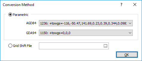
Parametric
Choose from a list of parameters for each coordinate system.
Grid shift file
Micromine will notify you if a conversion has an available grid shift file, which usually applies to conversions between modern and historic coordinate systems. To use a shift grid file:
- Click the Browse button at right of the Grid shift file response and choose the file.
- Be sure to use the file appropriate for your conversion.
This option is only enabled for specific conversions. For information on obtaining a grid shift file, visit the Coordinate System Resources page.
Background: Some conversions between historic and modern coordinate systems can’t be accurately described using a handful of parameters. This happens when historic coordinate systems contain local errors and irregularities that make them inaccurate by today’s standards. To overcome this limitation, modern conversions rely on shift grids (also known as transformation, distortion, or difference grids) to produce the most accurate result. A shift grid is simply a 2D mesh that covers the region of interest (typically a province or country), where each node in the mesh accurately defines the X and Y positional errors at that location. Applying the conversion is a case of interpolating the node values surrounding the location under investigation and using them to adjust the coordinate values.