Property Editor: Correlation Diagram
The Correlation Diagram Property Editor is opened when you create or edit a correlation diagram by selecting New | Correlation Diagram from the right-click menu under Drillhole Utilities in the Configuration Manager.
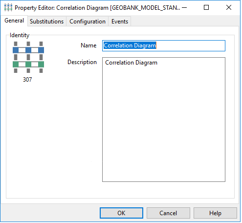
General
On the General tab of the Correlation Diagram Property Editor, set the general properties of the diagram.
Choose a short but descriptive name for the diagram.
To avoid potential problems, avoid using spaces or special characters in the name.
Optionally enter a Description that describes what data is associated with the diagram.
Configuration
Use the Configuration tab of the tab of the Correlation Diagram Property Editor, to configure the data, display and display scaling of the diagram.
The datasets used by the correlation diagram are set up in a very specific way. Before configuring the object, you should have a clear understanding of how these datasets are structured.
The correlation diagram uses three main datasets:
- collar survey data
- downhole interval data
- update query
These datasets are set up in a master-detail relationship, as shown below.
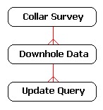
The update query is used to write changes back to the database. Note that this query can source values from the downhole dataset, using parameterised links.
The customised datasets are used “as is” when the correlation diagram is opened directly from the Geobank object tree. However, when the object is opened via the drillholes plan view, Geobank will replace your customised collar survey query with a new query based on the GB_VIEW_SITE_COORDS view, using the list of drillholes selected from the plan.
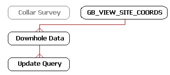
Typically, the SQL generated by the plan view will be similar to the following:
SELECT V.*
FROM DBO.GB_VIEW_SITE_COORDS AS V
WHERE
V.PROJECT = 'MYPROJECT'
AND V.SITE_ID IN ('BH040','BH016','BH033','BH006')
It is therefore important to ensure that the syntax for your customised collars query is compatible with the SQL that will be generated by the plan view.
Also, note that the correlation diagram requires the column END_DEPTH to be returned by the site coordinates view. This may require a change to the definition of the GB_VIEW_SITE_COORDS view in your source database.
See also:Opening the Correlation Diagram