The Database Properties form is displayed whenever you create or edit a drillhole database:
Properties
If downhole data is being used, then data in a Collar file and (optionally) a Survey file will be imported and used to generate trace coordinates. External interval and Event files can also be associated with the database. The fields in these files can be used to classify and colour code the trace display.
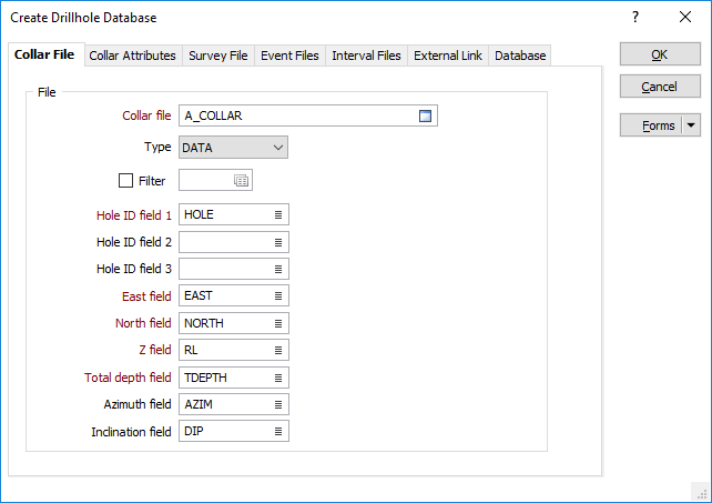
Collar file
Specify a Collar file, enter field settings and optionally apply a filter to create a subset of the data in the file. The Hole field should be a field containing unique hole identifier values.
Hole ID fields 1, 2, 3
Double-click to select the name of the fields that uniquely identify each hole in the file. Up to 3 Hole ID fields can be specified.
This can be useful, for example, when the holes imported from disparate datasets are known to have duplicate keys. When more than one Hole ID is specified, a unique ID (a concatenation of the Hole IDs) is used to query the database.
East and North and Z fields
Specify the names of the fields in which Easting, Northing, and Z coordinates are stored in the trench file.
Total depth field
Enter the name of the field containing the total depth (length) of each drillhole.
Azimuth field (Collar)
Enter the name of the field containing drillhole collar azimuths. Azimuths are expressed in decimal degrees, with zero (0°) being grid North. Negative values and values greater than 360° are correctly evaluated.
Inclination field (Collar)
Enter the inclination field of the collar file. Inclinations are expressed in decimal degrees from -90 to 90, with negative values representing down holes.
Event Files and Interval Files
Database (This tab is visible when you create a new database.)
Forms
Click the Forms button to select and open a saved form set, or if a form set has been loaded, save the current form set.
OK
Click OK to save the properties of the database you are creating or editing.